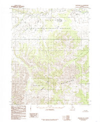
1985 Map of Shungnak B-3
USGS Topo · Published 1985About this map
The Purcell Mountains dominate this high-latitude landscape, where the Continental Divide winds through the southern reaches of the quadrangle. Established boundaries for the Selawik National Wildlife Refuge are clearly demarcated across the northern lowland, where the Selawik River and Shiniliakrok Creek meander through a complex network of wetlands and tundra. This 1985 provisional edition reflects the land status following the Alaska National Interest Lands Conservation Act of 1980, documenting a wilderness largely devoid of roads or trails. The map serves as a vital record for understanding the intersection of federal conservation efforts and the physical geography of the Yukon-Koyukuk region during a period of significant legislative land designation in Alaska.
Find a feature on this map
5 named features on this map. Tap any name to fly to it.
Don’t see what you’re looking for? This feature index may not catch every label — zoom into the map to look around manually.
Map Details
Editions of this 1985 Shungnak B-3 Map
This is the sole edition of this map. No revisions or reprints were ever made.
Other maps of this area

1951 · Shungnak
USGS Topo · 1:250,000

1955 · Shungnak
USGS Topo · 1:250,000

1964 · Shungnak
USGS Topo · 1:250,000

1985 · Shungnak B-4
USGS Topo · 1:63,360
1985 · Shungnak A-3
USGS Topo · 1:63,360
1985 · Shungnak A-4
USGS Topo · 1:63,360
1985 · Shungnak C-3
USGS Topo · 1:63,360
1985 · Shungnak B-2
USGS Topo · 1:63,360
1985 · Shungnak A-2
USGS Topo · 1:63,360
1985 · Shungnak C-2
USGS Topo · 1:63,360