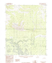
1985 Map of Shungnak A-2
USGS Topo · Published 1985About this map
The Purcell Mountains dominate the upper half of this mid-1980s survey, showing a landscape defined by dramatic elevation changes before descending into the complex wetlands of the Koyukuk National Wildlife Refuge. This transition from high peaks to the water-saturated lowlands highlights the isolated nature of the Alaskan interior, where human infrastructure is minimal and often functional rather than permanent. A Tractor Trail provides a rare terrestrial route through the terrain, winding past a lonely Cabin near the mountains' southern edge. Below the slopes, Hawk Creek meanders through a dense network of small lakes and ponds, illustrating the intricate drainage patterns of this subarctic wilderness during the late twentieth century.
Find a feature on this map
5 named features on this map. Tap any name to fly to it.
Don’t see what you’re looking for? This feature index may not catch every label — zoom into the map to look around manually.
Map Details
Editions of this 1985 Shungnak A-2 Map
This is the sole edition of this map. No revisions or reprints were ever made.
Other maps of this area

1951 · Shungnak
USGS Topo · 1:250,000

1951 · Kateel River
USGS Topo · 1:250,000

1954 · Kateel River D-1
USGS Topo · 1:63,360

1954 · Kateel River D-3
USGS Topo · 1:63,360

1955 · Shungnak
USGS Topo · 1:250,000

1955 · Kateel River D-2
USGS Topo · 1:63,360

1955 · Kateel River
USGS Topo · 1:250,000

1964 · Shungnak
USGS Topo · 1:250,000
1985 · Shungnak A-3
USGS Topo · 1:63,360
1985 · Shungnak B-3
USGS Topo · 1:63,360