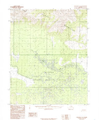
1985 Map of Shungnak A-3
USGS Topo · Published 1985About this map
The Purcell Mountains dominate the northern terrain of this mid-1980s Alaskan survey, rising steeply to the Continental Divide along the northwestern edge. This wilderness is largely defined by the sprawling Koyukuk National Wildlife Refuge, which covers the southern half of the map with a complex network of wetlands and seasonal water bodies. Billy Hawk Creek meanders through the central lowlands, providing a natural drainage for the upland slopes. Human presence is minimal and transient, evidenced primarily by a solitary Tractor Trail that cuts across the central landscape. The map illustrates the raw character of the Northwest Arctic and Yukon-Koyukuk borderlands before modern development, where the landscape is shaped more by hydrology and elevation than by settlement.
Find a feature on this map
5 named features on this map. Tap any name to fly to it.
Don’t see what you’re looking for? This feature index may not catch every label — zoom into the map to look around manually.
Map Details
Editions of this 1985 Shungnak A-3 Map
This is the sole edition of this map. No revisions or reprints were ever made.
Other maps of this area

1951 · Shungnak
USGS Topo · 1:250,000

1951 · Kateel River
USGS Topo · 1:250,000

1954 · Kateel River D-3
USGS Topo · 1:63,360

1954 · Kateel River D-4
USGS Topo · 1:63,360

1955 · Shungnak
USGS Topo · 1:250,000

1955 · Kateel River D-2
USGS Topo · 1:63,360

1955 · Kateel River
USGS Topo · 1:250,000

1964 · Shungnak
USGS Topo · 1:250,000

1985 · Shungnak B-4
USGS Topo · 1:63,360
1985 · Shungnak B-3
USGS Topo · 1:63,360