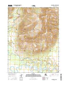
2016 Map of Shungnak D-2 NE
USGS Topo · Published 2016About this map
Ferguson Peak stands as the central topographic landmark in this section of the Arctic, overlooking a complex network of waterways that define the regional drainage. The southern portion of the landscape is dominated by the wide, meandering Kobuk River, which serves as the primary artery for the territory. Feeding into this system and the surrounding basins are numerous named streams including California Cr, Kogoluktuk River, and Kolioksak River. The map reveals a wild, unpopulated expanse where the names often suggest early exploration or local significance, such as Wonder Cr and Juanita Cr. This document provides a clear record of the hydrography and high-elevation terrain north of the Arctic Circle before later 21st-century environmental shifts, detailing the exact positions of smaller tributaries like Lynx Cr and Radio Cr as they descend from the high ridges toward the valley floors.
Find a feature on this map
20 named features on this map. Tap any name to fly to it.
Don’t see what you’re looking for? This feature index may not catch every label — zoom into the map to look around manually.
Map Details
Editions of this 2016 Shungnak D-2 NE Map
This is the sole edition of this map. No revisions or reprints were ever made.
Other maps of this area

1951 · Shungnak
USGS Topo · 1:250,000

1951 · Ambler River
USGS Topo · 1:250,000

1955 · Shungnak
USGS Topo · 1:250,000

1955 · Shungnak D-2
USGS Topo · 1:63,360

1956 · Ambler River
USGS Topo · 1:250,000

1964 · Shungnak
USGS Topo · 1:250,000

1964 · Ambler River
USGS Topo · 1:250,000
1985 · Ambler River A-2
USGS Topo · 1:63,360
1985 · Shungnak D-1
USGS Topo · 1:63,360
1985 · Ambler River A-1
USGS Topo · 1:63,360