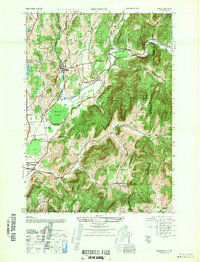
1947 Map of Shushan
USGS Topo · Published 1947About this map
The Batten Kill waterway winds through this corner of Washington County, defining the valley floor where the Delaware and Hudson railroad links rural hamlets just after World War II. The settlement at Shushan sits as a primary rail point, surrounded by agricultural pockets and named schoolhouses like School No 9 near Lake Lauderdale. To the east, the terrain rises sharply into the Taconics, marked by Dugway Mountain and the deep cuts of Murray Hollow and McKie Hollow. This 1947 Army Map Service edition captures a landscape still deeply rooted in 19th-century settlement patterns, evidenced by the scattered small-scale cemeteries like Binninger Cem and Camden Cem. Local researchers can trace old crossroads reaching into Vermont and the smaller clusters at Eagleville and Anaquassacook, as well as the marshy expanse of Eldridge Swamp south of the main river bend.
Find a feature on this map
41 named features on this map. Tap any name to fly to it.
Don’t see what you’re looking for? This feature index may not catch every label — zoom into the map to look around manually.
Map Details
Editions of this 1947 Shushan Map
This is the sole edition of this map. No revisions or reprints were ever made.
Other maps of this area

1894 · Equinox
USGS Topo · 1:62,500

1895 · Cambridge
USGS Topo · 1:62,500

1896 · Equinox
USGS Topo · 1:62,500

1897 · Hoosick
USGS Topo · 1:62,500

1898 · Cambridge
USGS Topo · 1:62,500

1898 · Bennington
USGS Topo · 1:62,500

1900 · Taconic
USGS Topo · 1:125,000

1900 · Equinox
USGS Topo · 1:62,500

1901 · Cambridge
USGS Topo · 1:62,500

1903 · Mettawee
USGS Topo · 1:125,000