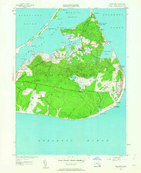
1951 Map of Siasconset
USGS Topo · Published 1963About this map
Nantucket's eastern shore is defined here by its unique mix of maritime infrastructure and agricultural history as documented in the early 1950s. The dense settlement of Siasconset sits perched on the coast, with the nearby Codfish Park and Sankaty Head lighthouse anchoring the easternmost edge of the island. Evidence of the island's former rail connection remains visible via an Abandoned Railroad Grade that cuts across the moors towards the Nantucket Memorial Airport.
Find a feature on this map
65 named features on this map. Tap any name to fly to it.
Don’t see what you’re looking for? This feature index may not catch every label — zoom into the map to look around manually.
Map Details
Editions of this 1951 Siasconset Map
4 editions found
Other maps of this area

1889 · Nantucket
USGS Topo · 1:62,500

1893 · Nantucket
USGS Topo · 1:62,500

1901 · Nantucket
USGS Topo · 1:62,500

1942 · Nantucket
USGS Topo · 1:125,000

1945 · Nantucket
USGS Topo · 1:31,680

1945 · Siasconset
USGS Topo · 1:31,680

1945 · Great Point
USGS Topo · 1:31,680

1947 · Providence
USGS Topo · 1:250,000

1948 · Providence
USGS Topo · 1:250,000

1951 · Great Point
USGS Topo · 1:31,680