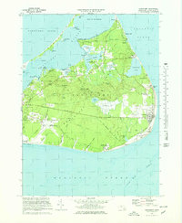
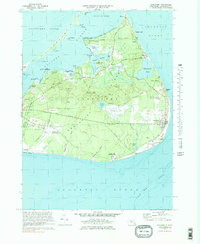
1972 Map of Siasconset
USGS Topo · Published 1978About this map
The eastern reaches of Nantucket Island are defined by a network of historic villages and coastal landmarks, from the narrow spit of Coatue Point to the prominent bluff at Sankaty Head. The 1970s landscape shows the transition from a maritime and agricultural economy to a residential and recreational one, evidenced by the presence of the Siasconset Golf Club and the Nantucket Memorial Airport. Local history is preserved in the trace of the Nantucket Railroad Grade, which once connected the town to the seaside village of Siasconset.
Find a feature on this map
73 named features on this map. Tap any name to fly to it.
Don’t see what you’re looking for? This feature index may not catch every label — zoom into the map to look around manually.
Map Details
Editions of this 1972 Siasconset Map
5 editions found
Other maps of this area

1889 · Nantucket
USGS Topo · 1:62,500

1893 · Nantucket
USGS Topo · 1:62,500

1901 · Nantucket
USGS Topo · 1:62,500

1942 · Nantucket
USGS Topo · 1:125,000

1945 · Nantucket
USGS Topo · 1:31,680

1945 · Siasconset
USGS Topo · 1:31,680

1945 · Great Point
USGS Topo · 1:31,680

1947 · Providence
USGS Topo · 1:250,000

1948 · Providence
USGS Topo · 1:250,000

1951 · Great Point
USGS Topo · 1:31,680