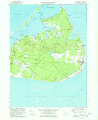
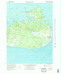
1972 Map of Siasconset
USGS Topo · Published 1978About this map
Siasconset and the eastern reaches of Nantucket appear here in the early 1970s, showcasing a landscape defined by its maritime heritage and specialized agriculture. The map detail highlights the traditional Cranberry Bog operations that once characterized the island's interior, alongside significant coastal landmarks like the Sankaty Head lighthouse and the Coast Guard Sta. A complex network of historic routes, including Milestone Road and the Bicycle Path, connects the seaside settlements of Wauwinet and Quidnet with the more developed Nantucket Memorial Airport to the south.
Find a feature on this map
84 named features on this map. Tap any name to fly to it.
Don’t see what you’re looking for? This feature index may not catch every label — zoom into the map to look around manually.
Map Details
Editions of this 1972 Siasconset Map
5 editions found
Other maps of this area

1889 · Nantucket
USGS Topo · 1:62,500

1893 · Nantucket
USGS Topo · 1:62,500

1901 · Nantucket
USGS Topo · 1:62,500

1942 · Nantucket
USGS Topo · 1:125,000

1945 · Nantucket
USGS Topo · 1:31,680

1945 · Siasconset
USGS Topo · 1:31,680

1945 · Great Point
USGS Topo · 1:31,680

1947 · Providence
USGS Topo · 1:250,000

1948 · Providence
USGS Topo · 1:250,000

1951 · Great Point
USGS Topo · 1:31,680