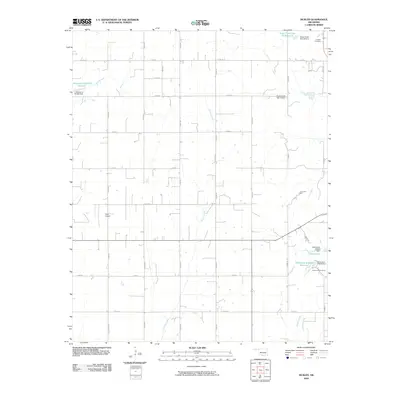
2009 Map of Sickles
USGS Topo · Published 2009About this map
Willow Creek and Keechi Creek drain the rural landscape of Caddo County in this early 21st-century survey. The terrain is structured by an extensive grid of section-line roads, including e1140 RD and e1200 RD, which facilitate movement between the region's agricultural plots and small landmarks. A series of flood control structures are prominent across the landscape, notably the Sugar Creek Site 39 Dam and several unnamed water bodies such as Oknoname 015013 Reservoir. Local activity is concentrated at specialized sites like King Airport and recreational areas including the Kiwanis Youth Camp and Camp Red Rock. For genealogists, the Lookeba Cemetery near the northeastern corner serves as an important point of reference for family histories in this part of Oklahoma.
Find a feature on this map
23 named features on this map. Tap any name to fly to it.
Don’t see what you’re looking for? This feature index may not catch every label — zoom into the map to look around manually.
Map Details
Editions of this 2009 Sickles Map
This is the sole edition of this map. No revisions or reprints were ever made.
Other maps of this area

1951 · Binger
USGS Topo · 1:62,500

1951 · Fort Cobb
USGS Topo · 1:62,500

1955 · Clinton
USGS Topo · 1:250,000

1957 · Clinton
USGS Topo · 1:250,000

1961 · Eakly
USGS Topo · 1:62,500

1961 · Carnegie
USGS Topo · 1:62,500

1979 · Hinton
USGS Topo · 1:24,000

1979 · Sickles
USGS Topo · 1:24,000
1979 · Fort Cobb Dam
USGS Topo · 1:24,000
1979 · Binger
USGS Topo · 1:24,000