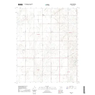
2018 Map of Sickles
USGS Topo · Published 2018About this map
Sickles serves as the focal point of this Caddo County landscape, where the agricultural grid meets the drainage patterns of the Southern Plains. The settlement is anchored by the Sickles Cem, while the Lookeba Cem sits to the northeast, providing essential landmarks for genealogical research in this rural corridor. The terrain is defined by the winding course of Willow Cr and Keechi Cr, which feed into several man-made catchments including the Sugar Cr Site 39 Reservoir and Hunt Lake. A notable topographical break occurs at Horseshoe Canyon in the southeast, contrasting with the otherwise steady sections of the Public Land Survey System. Transportation is limited to a dense network of county roads like Co RD 1140 and e1210 RD, supporting the local aviation through the small King Airport.
Find a feature on this map
37 named features on this map. Tap any name to fly to it.
Don’t see what you’re looking for? This feature index may not catch every label — zoom into the map to look around manually.
Map Details
Editions of this 2018 Sickles Map
This is the sole edition of this map. No revisions or reprints were ever made.
Other maps of this area

1951 · Binger
USGS Topo · 1:62,500

1951 · Fort Cobb
USGS Topo · 1:62,500

1955 · Clinton
USGS Topo · 1:250,000

1957 · Clinton
USGS Topo · 1:250,000

1961 · Eakly
USGS Topo · 1:62,500

1961 · Carnegie
USGS Topo · 1:62,500

1979 · Hinton
USGS Topo · 1:24,000

1979 · Sickles
USGS Topo · 1:24,000
1979 · Fort Cobb Dam
USGS Topo · 1:24,000
1979 · Binger
USGS Topo · 1:24,000