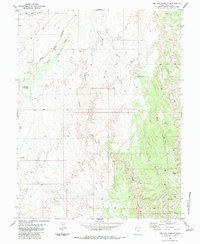
1983 Map of Sid and Charley
USGS Topo · Published 1983About this map
Sid and Charley, a pair of prominent rock towers, overlook a landscape of deep canyons and mesas in this 1983 survey of Emery County. The topography is defined by the high plateau of Secret Mesa and the striking cliffs of The Red Ledges, where drainage systems like Salt Wash and Eagle Canyon have carved complex patterns into the earth. The area shows little human development beyond a network of primitive routes, including several marked Jeep Trails and unnamed Trails that connect water sources like Cottonwood Spring. Geologic and topographic points of interest are numerous, ranging from a Natural Arch near Wood Hollow to a lone Drill Hole in the southwest quadrant. The map detail highlights the convergence of the North Fork Coal Wash and South Fork Coal Wash, illustrating the erosional forces that continue to shape this portion of the San Rafael Swell.
Find a feature on this map
32 named features on this map. Tap any name to fly to it.
Don’t see what you’re looking for? This feature index may not catch every label — zoom into the map to look around manually.
Map Details
Editions of this 1983 Sid and Charley Map
This is the sole edition of this map. No revisions or reprints were ever made.
Other maps of this area

1885 · San Rafael
USGS Topo · 1:250,000

1885 · Manti
USGS Topo · 1:250,000

1885 · Fish Lake
USGS Topo · 1:250,000

1886 · Price River
USGS Topo · 1:250,000

1895 · Manti
USGS Topo · 1:250,000

1896 · Price River
USGS Topo · 1:250,000

1896 · Fish Lake
USGS Topo · 1:250,000

1923 · Castle Dale
USGS Topo · 1:62,500

1925 · Castle Dale
USGS Topo · 1:62,500

1952 · San Rafael Knob
USGS Topo · 1:62,500