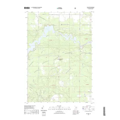
2019 Map of Sid Town
USGS Topo · Published 2019About this map
Huron National Forest dominates this section of Iosco County, where the Au Sable River valley has been transformed into a series of large reservoirs. The impounded waters of Cooke Dam Pond and Foote Dam Pond dictate the local geography, creating an expansive aquatic environment within the timberlands. This 2019 survey shows a landscape heavily utilized for recreation and resource management, defined by an intricate network of specialized paths including the Highbanks Trail and the Mi Shore to Shore Horse&Hike.
Find a feature on this map
50 named features on this map. Tap any name to fly to it.
Don’t see what you’re looking for? This feature index may not catch every label — zoom into the map to look around manually.
Map Details
Editions of this 2019 Sid Town Map
This is the sole edition of this map. No revisions or reprints were ever made.
Other maps of this area

1954 · Tawas City
USGS Topo · 1:250,000

1958 · Tawas City
USGS Topo · 1:250,000

1959 · Tawas City
USGS Topo · 1:62,500

1959 · East Tawas
USGS Topo · 1:62,500

1959 · Glennie
USGS Topo · 1:62,500

1959 · Harrisville
USGS Topo · 1:62,500

1983 · Hubbard Lake
USGS Topo · 1:100,000

1984 · Tawas City
USGS Topo · 1:100,000

1989 · Mikado
USGS Topo · 1:24,000
1989 · Glennie
USGS Topo · 1:24,000