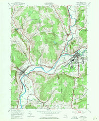
1943 Map of Sidney
USGS Topo · Published 1971About this map
The Susquehanna River and its confluence with the Unadilla River dominate this mid-century landscape at the intersection of Chenango, Delaware, and Otsego counties. The village of Sidney appears as a developed industrial and transportation hub, featuring a prominent Landing Field and an extensive grid of streets north of Sidney Mountain. Downriver to the west, Bainbridge serves as a secondary center, while smaller hamlets like Bennettsville, Yaleville, and East Guilford are scattered among the surrounding hills and hollows.
Find a feature on this map
40 named features on this map. Tap any name to fly to it.
Don’t see what you’re looking for? This feature index may not catch every label — zoom into the map to look around manually.
Map Details
Editions of this 1943 Sidney Map
3 editions found
Other maps of this area

1902 · Coventry
USGS Topo · 1:62,500

1904 · Oxford
USGS Topo · 1:62,500

1905 · Nineveh
USGS Topo · 1:62,500

1915 · Unadilla
USGS Topo · 1:62,500

1918 · Unadilla
USGS Topo · 1:62,500

1924 · Deposit
USGS Topo · 1:62,500

1926 · Deposit
USGS Topo · 1:62,500

1943 · Sidney
USGS Topo · 1:24,000

1943 · Gilbertsville
USGS Topo · 1:24,000
1943 · Unadilla
USGS Topo · 1:24,000