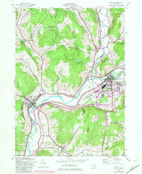
1943 Map of Sidney
USGS Topo · Published 1983About this map
The Susquehanna River and Unadilla River meet in a landscape defined by valley floor settlements and the steep rises of Sidney Mountain and Dingman Hill. This 1943 mapping, updated with 1981 photogrammetric revisions, documents the industrial and transit nodes of Sidney and Bainbridge during a period of mid-century growth. The Delaware and Hudson railroad corridor tracks the riverbanks, serving as a primary artery alongside historical junctions like East Guilford (New Berlin Junction). Smaller hamlets such as Bennettsville and Yaleville remain distinct, connected by rural routes like Searles Hill Road. The presence of the Municipal Airport and infrastructure like the Power Plant near the river reflects the modernization of the valley, while older family landmarks like Curtis Cem and Beals Cem preserve the area's genealogical footprint.
Find a feature on this map
45 named features on this map. Tap any name to fly to it.
Don’t see what you’re looking for? This feature index may not catch every label — zoom into the map to look around manually.
Map Details
Editions of this 1943 Sidney Map
3 editions found
Other maps of this area

1902 · Coventry
USGS Topo · 1:62,500

1904 · Oxford
USGS Topo · 1:62,500

1905 · Nineveh
USGS Topo · 1:62,500

1915 · Unadilla
USGS Topo · 1:62,500

1918 · Unadilla
USGS Topo · 1:62,500

1924 · Deposit
USGS Topo · 1:62,500

1926 · Deposit
USGS Topo · 1:62,500

1943 · Sidney
USGS Topo · 1:24,000

1943 · Gilbertsville
USGS Topo · 1:24,000
1943 · Unadilla
USGS Topo · 1:24,000