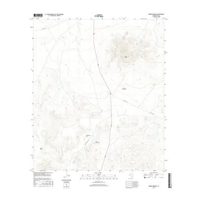
2016 Map of Sierra Madera
USGS Topo · Published 2016About this map
Sierra Madera rises as a distinct geological prominence in this 2016 survey of northern Pecos County, situated at the northeast fringe of the Glass Mountains. The landscape is defined by its arid-land drainage patterns, where ephemeral watercourses like Sixshooter Draw, Belding Draw, and Number Four Draw carve through the limestone-dominated terrain. These natural features indicate a long history of ranching reliance on seasonal runoff and groundwater, supported by localized infrastructure such as Home Pasture Tank and Huelem Tank. Transportation across this Trans-Pecos landscape is facilitated by a network of ranch roads including Montgomery Hill Rd, Esca Lera Rd, and Long Fellow Rd, which connect remote holdings to the broader region. This survey captures a moment of modern topographic detail in a territory where land use remains closely tied to the available water and the relief of the surrounding peaks.
Find a feature on this map
10 named features on this map. Tap any name to fly to it.
Don’t see what you’re looking for? This feature index may not catch every label — zoom into the map to look around manually.
Map Details
Editions of this 2016 Sierra Madera Map
This is the sole edition of this map. No revisions or reprints were ever made.
Other maps of this area

1920 · Longfellow
USGS Topo · 1:125,000

1923 · Hess Canyon
USGS Topo · 1:62,500

1923 · Sierra Madera
USGS Topo · 1:62,500

1928 · Comanche Spring
USGS Topo · 1:125,000

1929 · Hovey
USGS Topo · 1:125,000

1954 · Fort Stockton
USGS Topo · 1:250,000

1958 · Fort Stockton
USGS Topo · 1:250,000

1968 · Marathon Gap
USGS Topo · 1:24,000
1968 · Reininger Draw
USGS Topo · 1:24,000

1973 · Fort Stockton
USGS Topo · 1:250,000