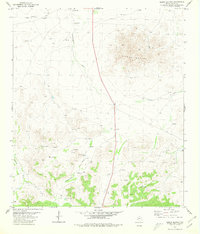
1980 Map of Sierra Madera
USGS Topo · Published 1980About this map
Sierra Madera dominates the northeastern landscape of this Pecos County region, a prominent geologic structure rising above the surrounding arid plains. In the early 1980s, this area reflects a ranching and energy-focused economy, where life is defined by the availability of water and the extraction of natural resources. Cattle ranching operations like Elsinore Ranch are supported by a series of engineered water sources including Canyon Tank, Home Pasture Tank, and Huelem Tank, alongside scattered wells like Lockwood Well.
Find a feature on this map
14 named features on this map. Tap any name to fly to it.
Don’t see what you’re looking for? This feature index may not catch every label — zoom into the map to look around manually.
Map Details
Editions of this 1980 Sierra Madera Map
This is the sole edition of this map. No revisions or reprints were ever made.
Other maps of this area

1920 · Longfellow
USGS Topo · 1:125,000

1923 · Hess Canyon
USGS Topo · 1:62,500

1923 · Sierra Madera
USGS Topo · 1:62,500

1928 · Comanche Spring
USGS Topo · 1:125,000

1929 · Hovey
USGS Topo · 1:125,000

1954 · Fort Stockton
USGS Topo · 1:250,000

1958 · Fort Stockton
USGS Topo · 1:250,000

1968 · Marathon Gap
USGS Topo · 1:24,000
1968 · Reininger Draw
USGS Topo · 1:24,000

1973 · Fort Stockton
USGS Topo · 1:250,000