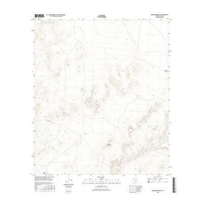
2016 Map of Sierra Madera SE
USGS Topo · Published 2016About this map
The Glass Mountains dominate this high-desert landscape in Pecos County, characterized by their steep elevation changes and intricate drainage patterns. The map reveals a ranching-focused economy where water management is central to the land's utility, marked by a series of named livestock tanks including Tully Taylor Tank, Bill Taylor Tank, and Mitchell Tank. These features, often named for the families who worked this land, highlight the historical and modern importance of artificial water sources in the Trans-Pecos region. Transportation across the area is limited to Longfellow Rd and a network of secondary tracks, illustrating the isolation of this western Texas terrain. The presence of features like Lemon Tank and Number Nine Tank near ephemeral drainages such as Nineteen Draw underscores the seasonal nature of water flow and its critical role in sustaining life and industry in the foothills of the Glass Mountains.
Find a feature on this map
8 named features on this map. Tap any name to fly to it.
Don’t see what you’re looking for? This feature index may not catch every label — zoom into the map to look around manually.
Map Details
Editions of this 2016 Sierra Madera SE Map
This is the sole edition of this map. No revisions or reprints were ever made.
Other maps of this area

1920 · Longfellow
USGS Topo · 1:125,000

1923 · Sierra Madera
USGS Topo · 1:62,500

1928 · Comanche Spring
USGS Topo · 1:125,000

1954 · Fort Stockton
USGS Topo · 1:250,000

1958 · Fort Stockton
USGS Topo · 1:250,000

1968 · Marathon Gap
USGS Topo · 1:24,000

1968 · Ebers Camp
USGS Topo · 1:24,000
1968 · Reininger Draw
USGS Topo · 1:24,000

1973 · Fort Stockton
USGS Topo · 1:250,000
1980 · Sierra Madera SE
USGS Topo · 1:24,000