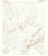
1980 Map of Sierra Madera SE
USGS Topo · Published 1980About this map
Water management dominates this arid West Texas landscape in Pecos County, where numerous earthen tanks and wells supported ranching operations in the late 1970s. Named features like Lemon Tank and Talley Taylor Tank indicate the vital role of specific family-held water sources in this environment. The terrain is defined by dry watercourses such as Number Four Draw and Nineteen Draw, which channel seasonal runoff through the hilly topography. Human activity is further evidenced by a remote Landing Strip and occasional exploration sites marked as Drill Hole. This survey provides a record of the infrastructure necessary for life and industry in the high desert, documenting the scattered network of Mitchell Tank and Number Nine Tank across the territory.
Find a feature on this map
11 named features on this map. Tap any name to fly to it.
Don’t see what you’re looking for? This feature index may not catch every label — zoom into the map to look around manually.
Map Details
Editions of this 1980 Sierra Madera SE Map
This is the sole edition of this map. No revisions or reprints were ever made.
Other maps of this area

1920 · Longfellow
USGS Topo · 1:125,000

1923 · Sierra Madera
USGS Topo · 1:62,500

1928 · Comanche Spring
USGS Topo · 1:125,000

1954 · Fort Stockton
USGS Topo · 1:250,000

1958 · Fort Stockton
USGS Topo · 1:250,000

1968 · Marathon Gap
USGS Topo · 1:24,000

1968 · Ebers Camp
USGS Topo · 1:24,000
1968 · Reininger Draw
USGS Topo · 1:24,000

1973 · Fort Stockton
USGS Topo · 1:250,000
1980 · Panther Tank
USGS Topo · 1:24,000