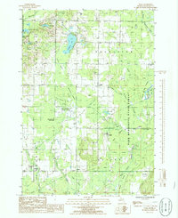
1985 Map of Sigma
USGS Topo · Published 1986About this map
The Pere Marquette State Forest dominates this Kalkaska County landscape, where the headwaters of the Boardman River and the North Branch Manistee River carve through a network of wetlands. Small settlements like Sigma, Cotton, and Spencer are linked by a grid of rural roads and forest grades, reflecting the region's history of logging and early 20th-century agriculture. The presence of numerous gas wells and a gravel pit suggests the mid-century industrial shift toward resource extraction. Natural features like Crawford Lake and Kniss Lake are interspersed with extensive cedar and tamarack swamps such as Schlemmer Swamp and Riley Swamp, providing a detailed view of the glacial drainage patterns that define this part of Northern Michigan. A local cemetery and the Radio Tower WGTV provide specific landmarks for genealogists and local historians.
Find a feature on this map
37 named features on this map. Tap any name to fly to it.
Don’t see what you’re looking for? This feature index may not catch every label — zoom into the map to look around manually.
Map Details
Editions of this 1985 Sigma Map
This is the sole edition of this map. No revisions or reprints were ever made.
Other maps of this area

1949 · Black Creek
USGS Topo · 1:24,000

1949 · Fletcher
USGS Topo · 1:62,500

1950 · Fletcher
USGS Topo · 1:24,000

1954 · Traverse City
USGS Topo · 1:250,000

1956 · Alba
USGS Topo · 1:62,500

1956 · Mancelona
USGS Topo · 1:62,500

1956 · Kalkaska
USGS Topo · 1:62,500

1958 · Traverse City
USGS Topo · 1:250,000

1983 · Traverse City
USGS Topo · 1:100,000
1983 · Grayling
USGS Topo · 1:100,000