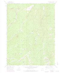
1954 Map of Signal Butte
USGS Topo · Published 1978About this map
Pike National Forest lands dominate this mid-century survey of the Colorado front range, centered on the prominent landmark of Signal Butte. The map documents a landscape defined by ranching and forest management, where isolated holdings like Turkey Rock Ranch, Lost Valley Ranch, and Rideout Ranch sit among a complex drainage network. The presence of the Old Phantom Creek Ranger Station (Site) marks a point of historical forest administration near the center of the sheet.
Find a feature on this map
31 named features on this map. Tap any name to fly to it.
Don’t see what you’re looking for? This feature index may not catch every label — zoom into the map to look around manually.
Map Details
Editions of this 1954 Signal Butte Map
4 editions found
Other maps of this area

1893 · Platte Canyon
USGS Topo · 1:125,000

1894 · Pikes Peak
USGS Topo · 1:125,000

1901 · Pikes Peak
USGS Topo · 1:125,000

1901 · Pikes Peak
USGS Topo · 1:62,500

1953 · Denver
USGS Topo · 1:250,000

1954 · Mount Deception
USGS Topo · 1:24,000

1954 · Woodland Park
USGS Topo · 1:24,000

1954 · Signal Butte
USGS Topo · 1:24,000

1954 · Divide
USGS Topo · 1:24,000

1954 · Pueblo
USGS Topo · 1:250,000