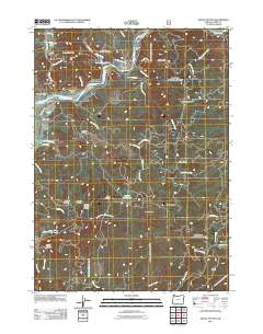
2011 Map of Signal Buttes
USGS Topo · Published 2011About this map
Bagnell Ferry and the Rogue River corridor anchor this coastal Oregon landscape, where river bars and high prairies define the settlement patterns. The map highlights the historic presence of family and community sites, such as the Rumley Hill Cemetery and Merriam Cemetery located north of the river. Moving south into the Siskiyou National Forest, the terrain rises toward Signal Buttes and Grizzly Mountain, punctuated by remote clearings like Hooter Scooter Prairie and Wagontire Prairie.
Find a feature on this map
65 named features on this map. Tap any name to fly to it.
Don’t see what you’re looking for? This feature index may not catch every label — zoom into the map to look around manually.
Map Details
Editions of this 2011 Signal Buttes Map
This is the sole edition of this map. No revisions or reprints were ever made.
Other maps of this area

1899 · Port Orford
USGS Topo · 1:125,000

1903 · Port Orford
USGS Topo · 1:125,000

1954 · Coos Bay
USGS Topo · 1:250,000

1954 · Port Orford
USGS Topo · 1:62,500

1954 · Gold Beach
USGS Topo · 1:62,500

1954 · Collier Butte
USGS Topo · 1:62,500

1954 · Agness
USGS Topo · 1:62,500

1958 · Coos Bay
USGS Topo · 1:250,000

1962 · Coos Bay
USGS Topo · 1:250,000
1986 · Ophir
USGS Topo · 1:24,000