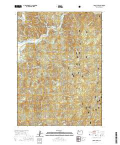
2020 Map of Signal Buttes
USGS Topo · Published 2020About this map
The Rogue River carves through this corner of Curry County, defining the geography with its series of gravel bars and landing points. As part of the Rogue Wild and Scenic River system, the waterway is flanked by landforms such as Canfield Bar, Kimball Bar, and Orchard Bar. Historical land use is evident in the presence of the Merriam Cem and Rumley Hill Cem, suggesting family plots or small community burials situated on the hills overlooking the river valley. To the south, the terrain transitions into the dense woods of the Siskiyou National Forest, where the topography rises toward Signal Buttes and Grizzly Mtn. Water features like Lake of the Woods and the Hunter Creek Bog highlight the complex hydrology of this coastal mountain range before the streams descend toward the Pacific.
Find a feature on this map
58 named features on this map. Tap any name to fly to it.
Don’t see what you’re looking for? This feature index may not catch every label — zoom into the map to look around manually.
Map Details
Editions of this 2020 Signal Buttes Map
This is the sole edition of this map. No revisions or reprints were ever made.
Other maps of this area

1899 · Port Orford
USGS Topo · 1:125,000

1903 · Port Orford
USGS Topo · 1:125,000

1954 · Coos Bay
USGS Topo · 1:250,000

1954 · Port Orford
USGS Topo · 1:62,500

1954 · Gold Beach
USGS Topo · 1:62,500

1954 · Collier Butte
USGS Topo · 1:62,500

1954 · Agness
USGS Topo · 1:62,500

1958 · Coos Bay
USGS Topo · 1:250,000

1962 · Coos Bay
USGS Topo · 1:250,000
1986 · Ophir
USGS Topo · 1:24,000