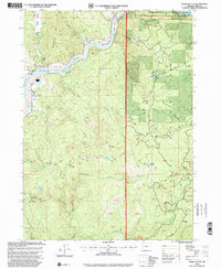
1998 Map of Signal Buttes
USGS Topo · Published 2001About this map
The Rogue River dominates this landscape, winding through Curry County alongside the Coquille Scenic Byway. The map captures a mix of river-bottom settlements and high-elevation landmarks, from the cluster at Jerrys Flat to the remote Pickle Ranch (Site) near the confluence of Hunter Creek. The terrain is characterized by numerous river bars such as Coyote Bar and Orchard Bar, and named riffles like Hawkins Riffle and Gillespie Riffle, which reflect the historic river navigation and recreation patterns of the region.
Find a feature on this map
58 named features on this map. Tap any name to fly to it.
Don’t see what you’re looking for? This feature index may not catch every label — zoom into the map to look around manually.
Map Details
Editions of this 1998 Signal Buttes Map
This is the sole edition of this map. No revisions or reprints were ever made.
Other maps of this area

1899 · Port Orford
USGS Topo · 1:125,000

1903 · Port Orford
USGS Topo · 1:125,000

1954 · Coos Bay
USGS Topo · 1:250,000

1954 · Port Orford
USGS Topo · 1:62,500

1954 · Gold Beach
USGS Topo · 1:62,500

1954 · Collier Butte
USGS Topo · 1:62,500

1954 · Agness
USGS Topo · 1:62,500

1958 · Coos Bay
USGS Topo · 1:250,000

1962 · Coos Bay
USGS Topo · 1:250,000
1986 · Ophir
USGS Topo · 1:24,000