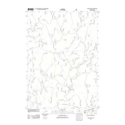
2012 Map of Signal Hill
USGS Topo · Published 2012About this map
Signal Hill rises above a high-plains landscape defined by seasonal drainages and scattered ranching operations in the early 21st century. The map reveals a network of water sources essential for livestock and settlement, including Bear Spring Cr, Alkali Spring, and Blacktail Spring. Private holdings such as the Elliot Ranch, Gahl Ranch, and Hammock Ranch are connected by a system of Forest Service roads and local routes like Ditch Creek Rd and Co Hwy 284. The terrain is marked by distinctive features including Elliot Ridge and Limestone Hill, while dry-wash navigation is guided by prominent landmarks like Lemming Draw and Windmill Draw. This document illustrates the persistent importance of named springs and remote homesteads in the rural Black Hills region, detailing the infrastructure of the Highland Park area and the sprawling drainage systems of Short Fork and Mud Spring.
Find a feature on this map
54 named features on this map. Tap any name to fly to it.
Don’t see what you’re looking for? This feature index may not catch every label — zoom into the map to look around manually.
Map Details
Editions of this 2012 Signal Hill Map
This is the sole edition of this map. No revisions or reprints were ever made.
Other maps of this area

1896 · Harney Peak
USGS Topo · 1:125,000

1901 · Harney Peak
USGS Topo · 1:125,000

1954 · Fourmile
USGS Topo · 1:24,000

1954 · Berne
USGS Topo · 1:24,000

1955 · Dead Horse Flats
USGS Topo · 1:24,000

1955 · Jewel Cave NW
USGS Topo · 1:24,000

1955 · Jewel Cave
USGS Topo · 1:24,000

1955 · Signal Hill
USGS Topo · 1:24,000

1955 · Hot Springs
USGS Topo · 1:250,000
1956 · Custer
USGS Topo · 1:62,500