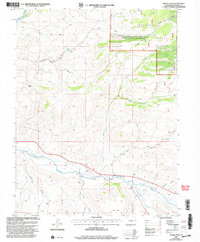
2001 Map of Signal Peak
USGS Topo · Published 2004About this map
The confluence of Tomichi Creek and Cochetopa Creek defines the southern portion of this high-elevation landscape, where open river valleys meet the rising slopes of the Gunnison National Forest. Topographic data from the early 1960s updated with 1990s imagery reveals a terrain shaped by water and work, from the prominent Signal Peak in the west to the numerous unnamed prospects and gravel pits that indicate long-standing local mineral and aggregate extraction.
Find a feature on this map
23 named features on this map. Tap any name to fly to it.
Don’t see what you’re looking for? This feature index may not catch every label — zoom into the map to look around manually.
Map Details
Editions of this 2001 Signal Peak Map
This is the sole edition of this map. No revisions or reprints were ever made.
Other maps of this area

1941 · Pitkin
USGS Topo · 1:62,500

1945 · Pitkin
USGS Topo · 1:62,500

1954 · Iris NW
USGS Topo · 1:24,000

1954 · Gunnison
USGS Topo · 1:24,000

1956 · Montrose
USGS Topo · 1:250,000

1959 · Montrose
USGS Topo · 1:250,000

1960 · Montrose
USGS Topo · 1:250,000

1962 · Iris
USGS Topo · 1:24,000

1962 · Houston Gulch
USGS Topo · 1:24,000
1964 · Flat Top
USGS Topo · 1:24,000