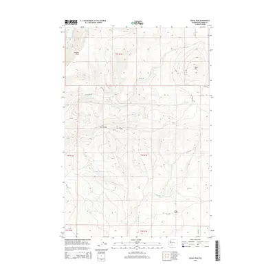
2014 Map of Signal Peak
USGS Topo · Published 2014About this map
Signal Peak rises as the dominant landmark in this high-elevation landscape within Yakima County, where the terrain is defined by a series of prominent ridges and deep creek drainages. To the west, the Klickitat River cuts through the northwest corner, while the interior is carved by Surveyors Cr, Trout Cr, and Pole Cr. The map reveals a complex network of Bureau of Indian Affairs (BIA) routes, such as BIA 140 Rd and BIA 220 Rd, which provide access to high points like Peavine Ridge and Pinegrass Ridge. These roads facilitate movement across the high country, connecting isolated points like Saxton Rock and the low-lying Cedar Valley. The presence of Jungle Spring highlights the critical, scattered water sources found throughout this upland environment, which remains largely characterized by natural features rather than concentrated settlements.
Find a feature on this map
30 named features on this map. Tap any name to fly to it.
Don’t see what you’re looking for? This feature index may not catch every label — zoom into the map to look around manually.
Map Details
Editions of this 2014 Signal Peak Map
This is the sole edition of this map. No revisions or reprints were ever made.
Other maps of this area

1904 · Mount Adams
USGS Topo · 1:125,000

1907 · Mount Adams
USGS Topo · 1:125,000

1950 · Yakima
USGS Topo · 1:250,000

1958 · Yakima
USGS Topo · 1:250,000

1961 · Yakima
USGS Topo · 1:250,000
1968 · Twin Buttes
USGS Topo · 1:24,000
1969 · Castile Falls
USGS Topo · 1:24,000
1970 · Outlet Falls
USGS Topo · 1:24,000
1970 · Lost Horse Plateau
USGS Topo · 1:24,000
1970 · Glenwood
USGS Topo · 1:24,000