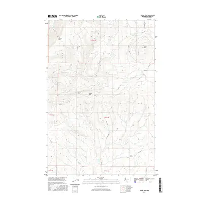
2017 Map of Signal Peak
USGS Topo · Published 2017About this map
Signal Peak and the high ridges of the Yakima back country dominate this landscape, which is defined by a dense network of Bureau of Indian Affairs access roads. The terrain is deeply incised by the Klickitat River in the northwest and numerous drainages like Surveyors Cr and Trout Cr that carve through the volcanic topography. Local landmarks such as Saxton Rock and the high Pinegrass Ridge overlook a region where land management and natural resource access are the primary human imprints. This environment is structured by the Public Land Survey System, with township and range lines like t9n r13e and t8n r13e organizing the vast timber and watershed areas. The presence of Jungle Spring and Cedar Valley indicates the essential role water sources play in navigating these high-elevation forest and rangelands, which are primarily reachable via designated routes like Panther Creek Rd and Pinegrass Ridge Rd.
Find a feature on this map
33 named features on this map. Tap any name to fly to it.
Don’t see what you’re looking for? This feature index may not catch every label — zoom into the map to look around manually.
Map Details
Editions of this 2017 Signal Peak Map
This is the sole edition of this map. No revisions or reprints were ever made.
Other maps of this area

1904 · Mount Adams
USGS Topo · 1:125,000

1907 · Mount Adams
USGS Topo · 1:125,000

1950 · Yakima
USGS Topo · 1:250,000

1958 · Yakima
USGS Topo · 1:250,000

1961 · Yakima
USGS Topo · 1:250,000
1968 · Twin Buttes
USGS Topo · 1:24,000
1969 · Castile Falls
USGS Topo · 1:24,000
1970 · Outlet Falls
USGS Topo · 1:24,000
1970 · Lost Horse Plateau
USGS Topo · 1:24,000
1970 · Glenwood
USGS Topo · 1:24,000