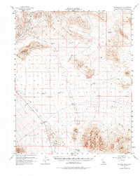
1956 Map of Silurian Hills
USGS Topo · Published 1976About this map
The arid landscape of the Silurian Lake basin is defined by the ephemeral tracks of desert hydrology and the remnants of early 20th-century transport networks. By the mid-1950s, several outposts along the former Tonopah and Tidewater Railroad corridor had transitioned to historical markers, including Sperry, Dumont, and Valjean. The presence of an Old Railroad Grade stretching through the Valjean Valley serves as a reminder of the region's mining and railroad era, while the active settlement at Renoville provides a contrast to the surrounding ghost sites like Riggs. Desert geography dominates the sheet, from the shifting Dumont Sand Dunes to the intricate drainage patterns of Kingston Wash and Salt Creek, which terminate in the expansive playa of the Silurian dry lake bed.
Find a feature on this map
19 named features on this map. Tap any name to fly to it.
Don’t see what you’re looking for? This feature index may not catch every label — zoom into the map to look around manually.
Map Details
Editions of this 1956 Silurian Hills Map
3 editions found

Other maps of this area

1910 · Ivanpah
USGS Topo · 1:250,000

1912 · Ivanpah
USGS Topo · 1:250,000

1933 · Avawatz Mountains
USGS Topo · 1:250,000

1942 · Ivanpah
USGS Topo · 1:250,000

1947 · Trona
USGS Topo · 1:250,000

1947 · Kingman
USGS Topo · 1:250,000

1948 · Kingman
USGS Topo · 1:250,000

1948 · Red Pass Lake
USGS Topo · 1:62,500

1948 · Trona
USGS Topo · 1:250,000

1948 · Avawatz Pass
USGS Topo · 1:62,500