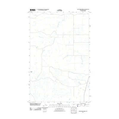
2011 Map of Silver Bow Spring
USGS Topo · Published 2011About this map
Silver Bow Spring serves as a vital water source in this high-plains landscape of Blaine County, Montana. The terrain is defined by the winding course of Woody Island Creek, which drains through a region of complex coulees and draws. Rising above the surrounding drainage patterns, Middle Butte stands as a prominent landmark in the southwestern portion of the map. The human footprint here is represented by a sparse network of section-line roads and ridge routes, including Cherry Ridge Rd and Summit Rd, which follow the natural contours of the high ground between creek beds. This 2011 survey by the U.S. Geological Survey illustrates a landscape of large-scale ranching and open range, where the placement of roads and the location of perennial water sources like the spring dictate the movement of people and livestock across the northern Montana plains.
Find a feature on this map
8 named features on this map. Tap any name to fly to it.
Don’t see what you’re looking for? This feature index may not catch every label — zoom into the map to look around manually.
Map Details
Editions of this 2011 Silver Bow Spring Map
This is the sole edition of this map. No revisions or reprints were ever made.
Other maps of this area

1903 · Wayne Creek
USGS Topo · 1:62,500

1905 · Wayne Creek
USGS Topo · 1:62,500

1905 · Harlem
USGS Topo · 1:62,500

1913 · Cherry Ridge
USGS Topo · 1:125,000

1953 · Havre
USGS Topo · 1:250,000

1957 · Havre
USGS Topo · 1:250,000

1958 · Havre
USGS Topo · 1:250,000
1984 · Harlem NW
USGS Topo · 1:24,000
1984 · Silver Bow Lake
USGS Topo · 1:24,000
1984 · Wayne Creek NW
USGS Topo · 1:24,000