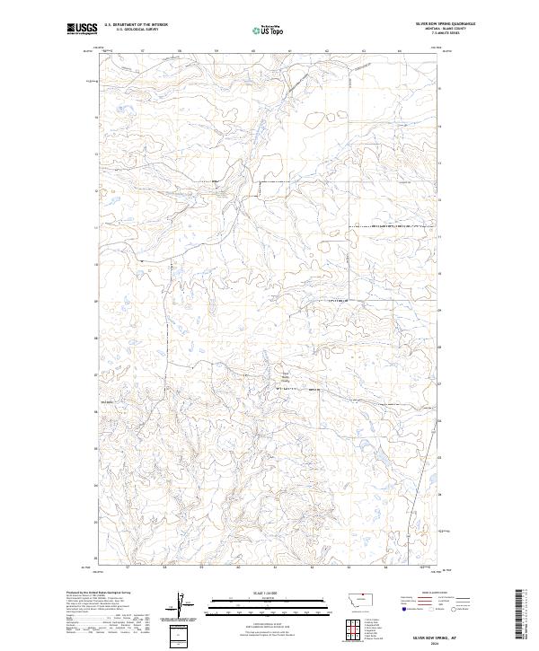
2024 Map of Silver Bow Spring
USGS Topo · Published 2024About this map
Springs and ephemeral drainage channels define this section of Blaine County, where the high plains landscape is marked by subtle topographic shifts. Silver Bow Spring and Senechal Spring are key water sources in this arid northern Montana environment, while the relief is punctuated by the isolated rise of Mid Butte in the southwestern quadrant. The drainage pattern is complex, with seasonal flows moving through Woody Island Coulee and Woody Island Creek toward the north, and the East Branch Thirtymile Creek carving southward.
Find a feature on this map
16 named features on this map. Tap any name to fly to it.
Don’t see what you’re looking for? This feature index may not catch every label — zoom into the map to look around manually.
Map Details
Editions of this 2024 Silver Bow Spring Map
This is the sole edition of this map. No revisions or reprints were ever made.
Other maps of this area

1903 · Wayne Creek
USGS Topo · 1:62,500

1905 · Wayne Creek
USGS Topo · 1:62,500

1905 · Harlem
USGS Topo · 1:62,500

1913 · Cherry Ridge
USGS Topo · 1:125,000

1953 · Havre
USGS Topo · 1:250,000

1957 · Havre
USGS Topo · 1:250,000

1958 · Havre
USGS Topo · 1:250,000
1984 · Harlem NW
USGS Topo · 1:24,000
1984 · Silver Bow Lake
USGS Topo · 1:24,000
1984 · Wayne Creek NW
USGS Topo · 1:24,000