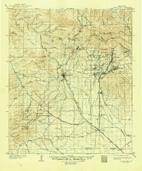
1909 Map of Silver City
USGS Topo · Published 1948About this map
Silver City serves as the central hub of this early twentieth-century survey, a landscape defined by the industrial and military activity of the New Mexico territory. To the east, the Fort Bayard Military Reservation and the sprawling operations at Santa Rita highlight the region's significance, with the Hanover Junction and the Union Hill Siding facilitating the transport of materials along the Atchison Topeka and Santa Fe railroad. The rugged topography is etched with numerous gulches and canyons, where small settlements like Fierro, Hanover, and Georgetown are clustered around productive mineral deposits.
Find a feature on this map
105 named features on this map. Tap any name to fly to it.
Don’t see what you’re looking for? This feature index may not catch every label — zoom into the map to look around manually.
Map Details
Editions of this 1909 Silver City Map
2 editions found
Other maps of this area

1899 · Deming
USGS Topo · 1:125,000

1909 · Silver City
USGS Topo · 1:125,000

1910 · Mogollon
USGS Topo · 1:125,000

1911 · Alum Mountain
USGS Topo · 1:125,000

1912 · Mogollon
USGS Topo · 1:125,000

1913 · Alum Mountain
USGS Topo · 1:125,000

1915 · Deming
USGS Topo · 1:125,000

1937 · Santa Rita
USGS Topo · 1:24,000

1947 · Allie Canyon
USGS Topo · 1:24,000

1947 · Twin Sisters
USGS Topo · 1:24,000