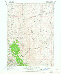
1965 Map of Silver City
USGS Topo · Published 1968About this map
Silver City and the surrounding mining districts in the Owyhee Mountains appear here during a mid-1960s survey, detailing a landscape defined by the legacies of 19th-century silver and gold rushes. The map provides precise locations for historically significant mining operations such as the Morning Star Mine, Poorman Mine, Oro Fino Mine, and Trade Dollar Mine, many concentrated around War Eagle Mtn and Florida Mtn. These labels, alongside the townsite of Dewey, represent the remnants of a once-booming industrial core.
Find a feature on this map
98 named features on this map. Tap any name to fly to it.
Don’t see what you’re looking for? This feature index may not catch every label — zoom into the map to look around manually.
Map Details
Editions of this 1965 Silver City Map
This is the sole edition of this map. No revisions or reprints were ever made.
Other maps of this area

1892 · Bisuka
USGS Topo · 1:125,000

1892 · Silver City
USGS Topo · 1:125,000

1894 · Bisuka
USGS Topo · 1:125,000

1894 · Silver City
USGS Topo · 1:125,000

1898 · Silver City
USGS Topo · 1:125,000

1948 · Sinker Butte
USGS Topo · 1:24,000

1949 · Sinker Butte
USGS Topo · 1:24,000

1949 · Oreana
USGS Topo · 1:62,500
1949 · Oreana
USGS Topo · 1:24,000
1950 · Oreana
USGS Topo · 1:24,000