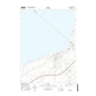
2016 Map of Silver Creek
USGS Topo · Published 2016About this map
Lake Erie defines the northern coastline of this Chautauqua County region, where the village of Silver Creek sits at the confluence of Walnut Creek and Silver Creek. The landscape transition from the waterfront settlements of Hanford Bay and Sunset Bay to the inland agricultural character of Hanover Center reveals a diverse pattern of development along the lake shore. Numerous beach communities, including Millers Beach, Wide Beach, and Lotus Point, line the northeastern coast, reflecting a long-standing history of seasonal and year-round residential growth by the water. Inland, the map documents significant local landmarks such as Mount Carmel Cemetery and Glenwood Cemetery, alongside a notable Race Track situated just south of the main village. The network of county roads, such as County Touring Route 79 and Route 85, connects these coastal points to the rural interior.
Find a feature on this map
60 named features on this map. Tap any name to fly to it.
Don’t see what you’re looking for? This feature index may not catch every label — zoom into the map to look around manually.
Map Details
Editions of this 2016 Silver Creek Map
This is the sole edition of this map. No revisions or reprints were ever made.
Other maps of this area

1899 · Silver Creek
USGS Topo · 1:62,500

1900 · Dunkirk
USGS Topo · 1:62,500

1900 · Cherry Creek
USGS Topo · 1:62,500

1941 · Cherry Creek
USGS Topo · 1:62,500

1943 · Dunkirk
USGS Topo · 1:62,500

1943 · Silver Creek
USGS Topo · 1:24,000
1944 · Angola
USGS Topo · 1:31,680

1944 · Farnham
USGS Topo · 1:31,680

1944 · Silver Creek
USGS Topo · 1:31,680

1954 · Forestville
USGS Topo · 1:24,000