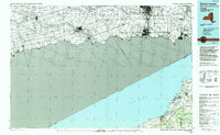
1986 Map of Silver Creek
USGS Topo · Published 1994About this map
The shoreline of Lake Erie dominates this late-twentieth-century study, illustrating the transition from the industrial waters of Ontario to the residential and agricultural communities of Western New York. The map details the complex geography where the Grand River and Cattaraugus Creek meet the lake, defining the borders of Hanover and the Cattaraugus Indian Reservation. While the northern shore shows the dense infrastructure around Haldimand, the New York side is characterized by smaller settlements like Silver Creek and Farnham.
Find a feature on this map
38 named features on this map. Tap any name to fly to it.
Don’t see what you’re looking for? This feature index may not catch every label — zoom into the map to look around manually.
Map Details
Editions of this 1986 Silver Creek Map
2 editions found
Other maps of this area

1894 · Buffalo
USGS Topo · 1:62,500

1894 · Niagara Falls
USGS Topo · 1:62,500

1896 · Niagara Falls
USGS Topo · 1:62,500

1897 · Tonawanda
USGS Topo · 1:62,500

1899 · Westfield
USGS Topo · 1:62,500

1899 · Silver Creek
USGS Topo · 1:62,500

1899 · Niagara
USGS Topo · 1:125,000

1900 · Dunkirk
USGS Topo · 1:62,500

1900 · Tonawanda
USGS Topo · 1:62,500

1900 · Cherry Creek
USGS Topo · 1:62,500