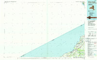
1986 Map of Silver Creek
USGS Topo · Published 1986About this map
Lake Erie defines the western edge of this 1980s-era planimetric study, where the shoreline is punctuated by local landmarks like Sturgeon Point Marina and Evangola State Park. The interior is shaped by the complex boundaries of the Cattaraugus Indian Reservation and the convergence of several major waterways, most notably Cattaraugus Creek and Walnut Creek.
Find a feature on this map
42 named features on this map. Tap any name to fly to it.
Don’t see what you’re looking for? This feature index may not catch every label — zoom into the map to look around manually.
Map Details
Editions of this 1986 Silver Creek Map
2 editions found
Other maps of this area

1894 · Buffalo
USGS Topo · 1:62,500

1894 · Niagara Falls
USGS Topo · 1:62,500

1896 · Niagara Falls
USGS Topo · 1:62,500

1897 · Tonawanda
USGS Topo · 1:62,500

1899 · Westfield
USGS Topo · 1:62,500

1899 · Silver Creek
USGS Topo · 1:62,500

1899 · Niagara
USGS Topo · 1:125,000

1900 · Dunkirk
USGS Topo · 1:62,500

1900 · Tonawanda
USGS Topo · 1:62,500

1900 · Cherry Creek
USGS Topo · 1:62,500