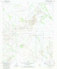
1981 Map of Silver Reef Mts.
USGS Topo · Published 1981About this map
The Silver Reef Mountains dominate this landscape within the Papago Indian Reservation, characterized by a complex history of desert mining and indigenous land use. Hard rock mining activity is concentrated in the northern peaks, where operations like the Magnesium Queen Mines, Silver Reef Mine, and Copper Standard Mines are mapped alongside several borrow pits and prospects. These sites cluster near the Shopishk (White Horse Pass), a natural gap that historically served as a critical passage through the desert terrain.
Find a feature on this map
30 named features on this map. Tap any name to fly to it.
Don’t see what you’re looking for? This feature index may not catch every label — zoom into the map to look around manually.
Map Details
Editions of this 1981 Silver Reef Mts. Map
3 editions found
Other maps of this area

1922 · Casa Grande
USGS Topo · 1:62,500

1922 · Signal Peak
USGS Topo · 1:62,500

1924 · Signal Peak
USGS Topo · 1:62,500

1924 · Casa Grande
USGS Topo · 1:62,500

1942 · Silver Reef Mountains
USGS Topo · 1:62,500

1947 · Eloy
USGS Topo · 1:62,500

1948 · Eloy
USGS Topo · 1:62,500

1956 · Tucson
USGS Topo · 1:250,000

1958 · Tucson
USGS Topo · 1:250,000

1959 · Tucson
USGS Topo · 1:250,000