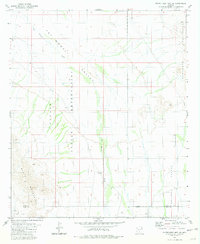
1981 Map of Silver Reef Mts. SE
USGS Topo · Published 1981About this map
The Papago Indian Reservation dominates the center of this landscape, where the seasonal drainage of Tat Momoli Wash carves a path through the desert basin. To the east and southwest, the terrain rises into the distinctive peaks of the Sawtooth Mountains and the Slate Mountains, including the prominent landmark known simply as Tooth. This 1981 survey illustrates a sparse desert environment where water and minerals dictated human presence, marked by isolated features like Corral Well and an unnamed Well. Evidence of small-scale exploration is visible in the southwestern corner, where a Mine and Prospect sit near the border of Pinal and Pima counties. The vast Aguirre Valley spreads across the eastern portion of the sheet, while a modern Substation indicates the encroachment of regional infrastructure into this traditional territory.
Find a feature on this map
13 named features on this map. Tap any name to fly to it.
Don’t see what you’re looking for? This feature index may not catch every label — zoom into the map to look around manually.
Map Details
Editions of this 1981 Silver Reef Mts. SE Map
3 editions found
Other maps of this area

1922 · Casa Grande
USGS Topo · 1:62,500

1922 · Signal Peak
USGS Topo · 1:62,500

1924 · Signal Peak
USGS Topo · 1:62,500

1924 · Casa Grande
USGS Topo · 1:62,500

1942 · Silver Reef Mountains
USGS Topo · 1:62,500

1947 · Eloy
USGS Topo · 1:62,500

1948 · Eloy
USGS Topo · 1:62,500

1956 · Tucson
USGS Topo · 1:250,000

1958 · Tucson
USGS Topo · 1:250,000

1959 · Tucson
USGS Topo · 1:250,000