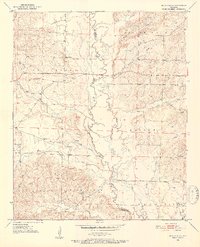
1951 Map of Silver Ridge
USGS Topo · Published 1952About this map
Silver Ridge stands as the namesake settlement in this 1951 topographic study of the Arkansas borderlands, situated near the boundary of Sevier and Howard Counties. The landscape is defined by the winding course of the Saline River, which is flanked by an intricate network of wetlands including Sulphur Slough, Cypress Slough, and Starch Slough. This drainage pattern significantly influenced the distribution of rural life, with community hubs like Milford and Steele Hill positioned away from the low-lying river bottoms.
Find a feature on this map
30 named features on this map. Tap any name to fly to it.
Don’t see what you’re looking for? This feature index may not catch every label — zoom into the map to look around manually.
Map Details
Editions of this 1951 Silver Ridge Map
3 editions found

Other maps of this area

1906 · Caddo Gap
USGS Topo · 1:125,000

1913 · De Queen
USGS Topo · 1:125,000

1950 · Mcalester
USGS Topo · 1:250,000

1950 · Ben Lomond
USGS Topo · 1:24,000

1950 · Falls Chapel
USGS Topo · 1:24,000

1951 · Ben Lomond
USGS Topo · 1:24,000

1951 · Falls Chapel
USGS Topo · 1:24,000

1951 · Mineral Springs South
USGS Topo · 1:24,000

1951 · Lockesburg
USGS Topo · 1:24,000

1951 · Mineral Springs North
USGS Topo · 1:24,000