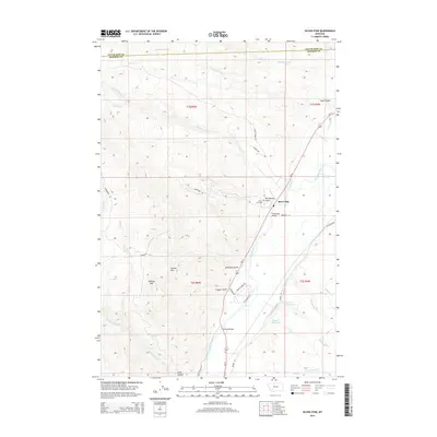
2014 Map of Silver Star
USGS Topo · Published 2014About this map
The settlement of Silver Star sits along the western bank of the Jefferson River, serving as a central point in this Madison County landscape. This 2014 survey captures the sophisticated water management systems vital to the region's agricultural and mining history, including the Creeklyn Ditch, Duffy Ditch, and Cornforth Ditch. The terrain shifts from the river valley to the prominent heights of Bulldog Mtn and the Ironrod Hills, with several gulches such as Blackman Gulch and Clipper Gulch cutting through the uplands. Infrastructure including the Silver Star Bridge and Ironrod Bridge facilitates movement across the river, while the Silver Star Cem and Tom Benton Gulch provide specific points of interest for genealogists and local historians tracing the area's development. Small-scale water storage is evidenced by the Nelson Reservoir and Miller Reservoir, which anchor the southern half of the quadrangle near Unnamed Spring Cr.
Find a feature on this map
83 named features on this map. Tap any name to fly to it.
Don’t see what you’re looking for? This feature index may not catch every label — zoom into the map to look around manually.
Map Details
Editions of this 2014 Silver Star Map
This is the sole edition of this map. No revisions or reprints were ever made.
Other maps of this area

1893 · Dillon
USGS Topo · 1:250,000

1955 · Dillon
USGS Topo · 1:250,000

1957 · Dillon
USGS Topo · 1:250,000

1958 · Dillon
USGS Topo · 1:250,000

1960 · Twin Bridges
USGS Topo · 1:62,500

1960 · Waterloo
USGS Topo · 1:62,500

1962 · Dillon
USGS Topo · 1:250,000

1963 · Pipestone Pass
USGS Topo · 1:24,000

1963 · Vendome
USGS Topo · 1:24,000
1963 · Grace
USGS Topo · 1:24,000