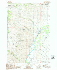
1989 Map of Silver Star
USGS Topo · Published 1989About this map
Mining operations and water management dominate this late 20th-century landscape along the Jefferson River valley. The small settlement of Silver Star serves as a focal point near the riverbank, situated just north of the Silver Star Fishing Access. To the west, the Ironrod Hills and the slopes of Bulldog Mountain are heavily marked by the region's extractive history, featuring numerous named workings such as the Keystone Mine, Victoria Mine, and Golden Rod Mine. These sites, along with various mine shafts and adits, indicate a rugged industrial environment where complex topography meets commercial enterprise.
Find a feature on this map
47 named features on this map. Tap any name to fly to it.
Don’t see what you’re looking for? This feature index may not catch every label — zoom into the map to look around manually.
Map Details
Editions of this 1989 Silver Star Map
This is the sole edition of this map. No revisions or reprints were ever made.
Other maps of this area

1893 · Dillon
USGS Topo · 1:250,000

1955 · Dillon
USGS Topo · 1:250,000

1957 · Dillon
USGS Topo · 1:250,000

1958 · Dillon
USGS Topo · 1:250,000

1960 · Twin Bridges
USGS Topo · 1:62,500

1960 · Waterloo
USGS Topo · 1:62,500

1962 · Dillon
USGS Topo · 1:250,000

1963 · Pipestone Pass
USGS Topo · 1:24,000

1963 · Vendome
USGS Topo · 1:24,000
1963 · Grace
USGS Topo · 1:24,000