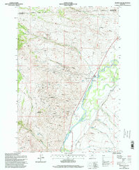
1996 Map of Silver Star
USGS Topo · Published 1998About this map
Mining operations and irrigation systems define the landscape around Silver Star during this mid-1990s update of a mid-century survey. The terrain transitions from the high peaks of the Blackman Hills and Bulldog Mountain down to the fertile corridor of the Jefferson River. Extensive mineral exploration is evident throughout the western highlands, marked by numerous Prospects, Adits, and significant operations such as the Keystone Mine, Victoria Mine, and the Stella Mine. These industrial features are balanced by the complex water management network on the valley floor, where the Parrot Ditch and Duffy Ditch carry water past the Miller Reservoir and Nelson Reservoir. This map preserves the layout of local infrastructure, from the Ironrod Bridge spanning the river to the rural connections of Benton Road and Bayers Lane.
Find a feature on this map
50 named features on this map. Tap any name to fly to it.
Don’t see what you’re looking for? This feature index may not catch every label — zoom into the map to look around manually.
Map Details
Editions of this 1996 Silver Star Map
This is the sole edition of this map. No revisions or reprints were ever made.
Other maps of this area

1893 · Dillon
USGS Topo · 1:250,000

1955 · Dillon
USGS Topo · 1:250,000

1957 · Dillon
USGS Topo · 1:250,000

1958 · Dillon
USGS Topo · 1:250,000

1960 · Twin Bridges
USGS Topo · 1:62,500

1960 · Waterloo
USGS Topo · 1:62,500

1962 · Dillon
USGS Topo · 1:250,000

1963 · Pipestone Pass
USGS Topo · 1:24,000

1963 · Vendome
USGS Topo · 1:24,000
1963 · Grace
USGS Topo · 1:24,000