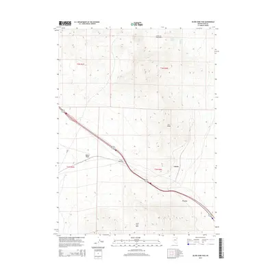
2014 Map of Silver Zone Pass
USGS Topo · Published 2014About this map
Silver Zone Pass serves as a critical corridor through the high desert of Elko County, where the Toano Range creates a formidable natural barrier. This 2014 survey documents the modern infrastructure following this historical transit route, primarily the path of Alt 93 as it descends from the pass into the Silver Zone Basin. The map captures the quiet, isolated character of the Great Basin, punctuated by named points like Silver Zone, Cliffside, and Proctor. These locations trace the alignment of the railroad through the basin, marking where rail operations and local topography meet. In the higher elevations to the north, the geography is defined by more specialized features such as the Collar and Elbow Basin, along with vital water sources like Toano Number Thirteen Spring and Collar and Elbow Spring, which underscore the importance of water management in this arid Nevada landscape.
Find a feature on this map
14 named features on this map. Tap any name to fly to it.
Don’t see what you’re looking for? This feature index may not catch every label — zoom into the map to look around manually.
Map Details
Editions of this 2014 Silver Zone Pass Map
This is the sole edition of this map. No revisions or reprints were ever made.
Other maps of this area

1955 · Wells
USGS Topo · 1:250,000

1955 · Elko
USGS Topo · 1:250,000

1958 · Wells
USGS Topo · 1:250,000

1958 · Elko
USGS Topo · 1:250,000

1961 · Wells
USGS Topo · 1:250,000

1962 · Elko
USGS Topo · 1:250,000

1965 · Elko
USGS Topo · 1:250,000
1967 · Pilot Peak SW
USGS Topo · 1:24,000

1967 · Cobre SE
USGS Topo · 1:24,000

1967 · Cobre
USGS Topo · 1:24,000