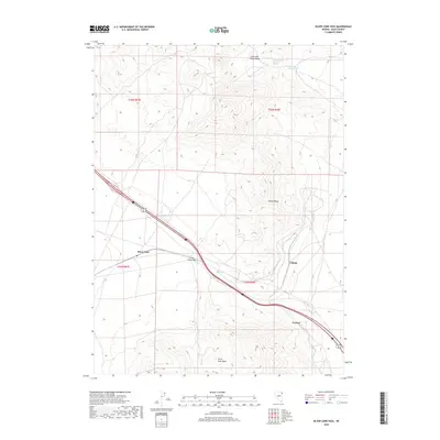
2018 Map of Silver Zone Pass
USGS Topo · Published 2018About this map
Silver Zone Pass serves as a critical corridor through the Toano Range in eastern Elko County. This high-desert landscape is defined by the sharp transition between the Collar and Elbow Basin to the north and the Silver Zone Basin to the south. Historically, the area represents a vital transit artery where the modern path of Interstate 80 and Alternate U.S. 93 follow established routes through the mountains. Small rail-side points such as Proctor, Cliffside, and Silver Zone line the corridor, marking the legacy of transport infrastructure in this arid terrain. Remote water sources like Toano Number Thirteen Spring and Collar and Elbow Spring provide rare points of relief in the high-elevation basin and range environment.
Find a feature on this map
15 named features on this map. Tap any name to fly to it.
Don’t see what you’re looking for? This feature index may not catch every label — zoom into the map to look around manually.
Map Details
Editions of this 2018 Silver Zone Pass Map
This is the sole edition of this map. No revisions or reprints were ever made.
Other maps of this area

1955 · Wells
USGS Topo · 1:250,000

1955 · Elko
USGS Topo · 1:250,000

1958 · Wells
USGS Topo · 1:250,000

1958 · Elko
USGS Topo · 1:250,000

1961 · Wells
USGS Topo · 1:250,000

1962 · Elko
USGS Topo · 1:250,000

1965 · Elko
USGS Topo · 1:250,000
1967 · Pilot Peak SW
USGS Topo · 1:24,000

1967 · Cobre SE
USGS Topo · 1:24,000

1967 · Cobre
USGS Topo · 1:24,000