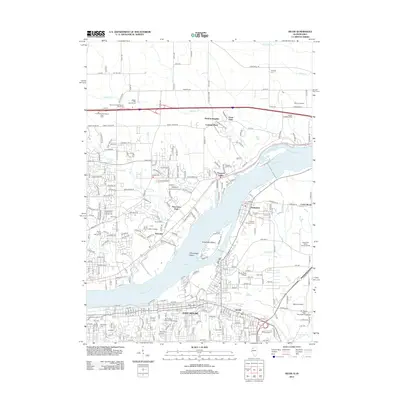
2012 Map of Silvis
USGS Topo · Published 2012About this map
The Mississippi River carves a wide path through this 2012 survey, defining the industrial and residential boundaries of eastern Scott County and western Rock Island County. Heavy development characterizes East Moline and Silvis, where tight street grids and the Saint Mary's Catholic Church mark established neighborhoods. In the river itself, Winnebago Island and Campbell's Island sit near the mouth of Sugar Creek, while the Le Claire Canal bypasses the main channel to the north. Higher elevations above the river bluffs contain suburban expansions like Panorama Park and Riverdale, alongside educational hubs including Scott Community College. The landscape is a mix of dense urban centers and managed green spaces, evidenced by the Hidden Hills Golf Course and multiple historic burial grounds such as Riverside Cem and Hampton Cem. Small aviation hubs like Schurr Airport and McNeals Field serve the surrounding communities north of the river.
Find a feature on this map
108 named features on this map. Tap any name to fly to it.
Don’t see what you’re looking for? This feature index may not catch every label — zoom into the map to look around manually.
Map Details
Editions of this 2012 Silvis Map
This is the sole edition of this map. No revisions or reprints were ever made.
Other maps of this area

1891 · Davenport
USGS Topo · 1:62,500

1892 · Leclaire
USGS Topo · 1:62,500

1893 · Leclaire
USGS Topo · 1:62,500

1894 · Davenport
USGS Topo · 1:62,500

1899 · Clinton
USGS Topo · 1:125,000

1901 · Rock Island
USGS Topo · 1:125,000

1910 · Rock Island
USGS Topo · 1:125,000

1912 · Milan
USGS Topo · 1:62,500

1937 · Orion
USGS Topo · 1:62,500

1944 · Milan
USGS Topo · 1:62,500