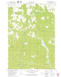
1979 Map of Simes Creek
USGS Topo · Published 1980About this map
The North Fork Eau Claire River winds through this rural landscape at the intersection of Chippewa, Eau Claire, and Clark counties. This 1970s survey captures a transition between the northern forested reaches of the Blue Swamp and the agricultural parcels of Wilson and Butler townships. Significant water features like Hamilton Falls and the Simes Creek Flowage define the local topography, while the Simes Creek Flowage Trail and Hamilton Falls Snowmobile Trail point to the area's established recreational use. Small-scale industrial activity is evidenced by a Sandpit and Gravel Pit, supporting the local infrastructure. Local community landmarks include the Pleasant Valley Ch and Township Memorial Park, while the Wilson Lookout Tower stands as a prominent navigational point in the southwestern quadrant.
Find a feature on this map
29 named features on this map. Tap any name to fly to it.
Don’t see what you’re looking for? This feature index may not catch every label — zoom into the map to look around manually.
Map Details
Editions of this 1979 Simes Creek Map
This is the sole edition of this map. No revisions or reprints were ever made.
Other maps of this area

1935 · Osseo
USGS Topo · 1:48,000

1940 · Osseo
USGS Topo · 1:62,500

1948 · Fairchild
USGS Topo · 1:62,500

1949 · Fairchild
USGS Topo · 1:62,500

1952 · Cadott
USGS Topo · 1:62,500

1952 · Stanley
USGS Topo · 1:62,500

1953 · Eau Claire
USGS Topo · 1:250,000

1958 · Eau Claire
USGS Topo · 1:250,000

1964 · Eau Claire
USGS Topo · 1:250,000
1968 · Osseo
USGS Topo · 1:62,500