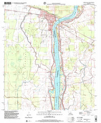
1998 Map of Simmesport
USGS Topo · Published 2002About this map
The Atchafalaya River serves as the central artery for this region of the Avoyelles Parish and Pointe Coupee Parish border. Significant engineering is evident in the extensive Levee systems and the West Atchafalaya Floodway, which shape the settlement patterns of Simmesport and outlying hamlets. The landscape is defined by a dense network of waterways including Bayou des Glaises, Yellow Bayou, and Brushy Bayou. Local social geography is anchored by numerous rural congregations and schools, such as Dunbar High Sch, St John Ch, and Mt Calvary Ch. The presence of an Old Railroad Grade and a Gaging Station near the river highlight the historical importance of both rail transport and water management in this low-lying riverine environment.
Find a feature on this map
34 named features on this map. Tap any name to fly to it.
Don’t see what you’re looking for? This feature index may not catch every label — zoom into the map to look around manually.
Map Details
Editions of this 1998 Simmesport Map
This is the sole edition of this map. No revisions or reprints were ever made.
Other maps of this area

1939 · Artonish
USGS Topo · 1:62,500

1941 · Voorhies
USGS Topo · 1:62,500

1941 · Batchelor
USGS Topo · 1:62,500

1953 · Natchez
USGS Topo · 1:250,000

1954 · Artonish
USGS Topo · 1:62,500

1954 · Baton Rouge
USGS Topo · 1:250,000

1955 · Artonish
USGS Topo · 1:62,500

1955 · Batchelor
USGS Topo · 1:62,500

1955 · Odenburg
USGS Topo · 1:62,500

1956 · Natchez
USGS Topo · 1:250,000