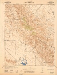
1943 Map of Simmler
USGS Topo · Published 1943About this map
Soda Lake dominates the southern basin of this 1943 survey, marking the lowest point of the Carrizo Plain where ephemeral waters collect in an endorheic basin. To the east, the steep rising slopes of the Temblor Range create a formidable barrier between the plain and the Central Valley beyond, with McKittrick Summit serving as a high-altitude passage. The map documents a sparsely populated ranching landscape defined by family operations such as the McAllister Ranch, Ross Ranch, and El Chicote Ranch. The small settlement at Simmler appears as the primary hub of activity for the region, complete with the Simmler School and a junction of state routes. This document, prepared under the direction of the War Department during the Second World War, provides a precise record of the remote canyons and springs, like Carneros Spring and Walnut Spring, that were vital for survival in this arid environment.
Find a feature on this map
28 named features on this map. Tap any name to fly to it.
Don’t see what you’re looking for? This feature index may not catch every label — zoom into the map to look around manually.
Map Details
Editions of this 1943 Simmler Map
This is the sole edition of this map. No revisions or reprints were ever made.
Other maps of this area

1912 · McKittrick
USGS Topo · 1:125,000

1914 · Lost Hills
USGS Topo · 1:125,000

1914 · Cholame
USGS Topo · 1:125,000

1915 · Cholame
USGS Topo · 1:125,000

1917 · Cholame
USGS Topo · 1:125,000
1932 · West of Goose Lake
USGS Topo · 1:31,680

1932 · La Panza
USGS Topo · 1:48,000
1934 · West of Goose Lake
USGS Topo · 1:31,680

1935 · La Panza
USGS Topo · 1:62,500
1936 · La Panza
USGS Topo · 1:62,500