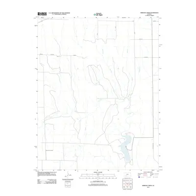
2012 Map of Simmons Creek
USGS Topo · Published 2012About this map
Clark County State Lake anchors the southeastern portion of this landscape, where the waters of Bluff Cr are impounded within the rolling plains of Ford County. The area is defined by a grid of rural section roads, including Co Line Rd, Zane Rd, and Yucca Rd, which divide the agricultural terrain. Aviation history is noted by the presence of Esplund Farm Airport, a private landing strip situated among the drainage basins of several local tributaries. These waterways, including Simmons Cr, Hargis Cr, and Rattlesnake Cr, create a dendritic drainage pattern across the prairie, shaping the local topography and the placement of the sparse farm infrastructure. The map illustrates a contemporary rural Kansas environment where modern land management and older transport routes converge around essential water resources.
Find a feature on this map
15 named features on this map. Tap any name to fly to it.
Don’t see what you’re looking for? This feature index may not catch every label — zoom into the map to look around manually.
Map Details
Editions of this 2012 Simmons Creek Map
This is the sole edition of this map. No revisions or reprints were ever made.
Other maps of this area

1892 · Spearville
USGS Topo · 1:125,000

1894 · Spearville
USGS Topo · 1:125,000

1896 · Ashland
USGS Topo · 1:125,000

1955 · Pratt
USGS Topo · 1:250,000

1959 · Pratt
USGS Topo · 1:250,000

1967 · Bloom
USGS Topo · 1:24,000
1969 · Fort Dodge SW
USGS Topo · 1:24,000

1969 · Bucklin
USGS Topo · 1:24,000

1969 · Kingsdown
USGS Topo · 1:24,000

1979 · Bloom SE
USGS Topo · 1:24,000