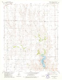
1979 Map of Simmons Creek
USGS Topo · Published 1980About this map
The Old Indian Treaty Boundary cuts through this rural landscape on the border of Ford and Clark counties, marking a significant historical line in the settlement of western Kansas. The terrain is defined by a network of drainage systems, including Simmons Creek, Brites Creek, and Hargis Creek, which flow toward the more prominent Bluff Creek in the south. In the late 1970s, the Clark State Fishing Lake and Wildlife Area serves as the primary recreational landmark, featuring a Boat Ramp, Picnic Areas, and the Spillway Elev 2252.
Find a feature on this map
19 named features on this map. Tap any name to fly to it.
Don’t see what you’re looking for? This feature index may not catch every label — zoom into the map to look around manually.
Map Details
Editions of this 1979 Simmons Creek Map
This is the sole edition of this map. No revisions or reprints were ever made.
Other maps of this area

1892 · Spearville
USGS Topo · 1:125,000

1894 · Spearville
USGS Topo · 1:125,000

1896 · Ashland
USGS Topo · 1:125,000

1955 · Pratt
USGS Topo · 1:250,000

1959 · Pratt
USGS Topo · 1:250,000

1967 · Bloom
USGS Topo · 1:24,000
1969 · Fort Dodge SW
USGS Topo · 1:24,000

1969 · Bucklin
USGS Topo · 1:24,000

1969 · Kingsdown
USGS Topo · 1:24,000

1979 · Bloom SE
USGS Topo · 1:24,000