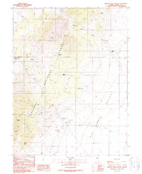
1989 Map of Simpson Park Canyon
USGS Topo · Published 1990About this map
Toiyabe National Forest dominates this high-altitude landscape in central Nevada, where steep drainage systems like Simpson Park Canyon descend toward the floor of the Big Smoky Valley. The map documents a rugged interior economy defined by isolated livestock ranching at Givens Ranch and a scattered history of mineral exploration. Numerous unnamed Prospects and Prospect sites dot the canyon walls, while more established operations like the Lowboy Mine and Cahill Mine appear tucked into the western slopes. Water is the primary driver of movement in this arid environment, evidenced by a dense network of vital points including Windlass Spring, Chimney Spring, and Bob Scotts Spring. A transition from federal forest land to the open basin is clearly marked by the shift in terrain as Blackbird Creek flows eastward toward the valley, providing a detailed look at the hydrology of Lander County during the late twentieth century.
Find a feature on this map
20 named features on this map. Tap any name to fly to it.
Don’t see what you’re looking for? This feature index may not catch every label — zoom into the map to look around manually.
Map Details
Editions of this 1989 Simpson Park Canyon Map
This is the sole edition of this map. No revisions or reprints were ever made.
Other maps of this area

1926 · Roberts Mountains
USGS Topo · 1:250,000

1929 · Roberts Mountains
USGS Topo · 1:250,000

1955 · Millett
USGS Topo · 1:250,000

1956 · Mount Callaghan
USGS Topo · 1:62,500

1956 · Austin
USGS Topo · 1:62,500

1959 · Millett
USGS Topo · 1:250,000

1960 · Spencer Hot Springs
USGS Topo · 1:62,500

1969 · Yankee Blade
USGS Topo · 1:24,000

1978 · Summit Mountain
USGS Topo · 1:100,000

1979 · Simpson Park Mtns
USGS Topo · 1:100,000